The main navigation menu allows you to select from a list of options and to use the available touch screen buttons to make system adjustments and plan routes.
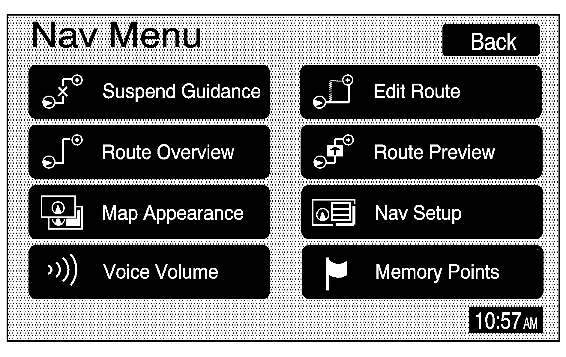
You will be able to select from the following items on the main navigation menu:
Suspend Guidance
(Suspend Guidance): Select this screen button from the Nav Menu to suspend guidance to all current and programmed destinations, but the current route will be retained in memory. You will no longer receive voice prompts for navigation. The map can still be viewed by pressing the NAV hard key. If you suspend guidance, you can touch the Resume Guidance screen button to resume the current route.Route Overview
(Route Overview): Select this screen button to display the map with the route highlighted. The total distance and estimated travel time will also display.Map Appearance
(Map Appearance): Select this screen button to adjust the appearance of a map based on your preferences.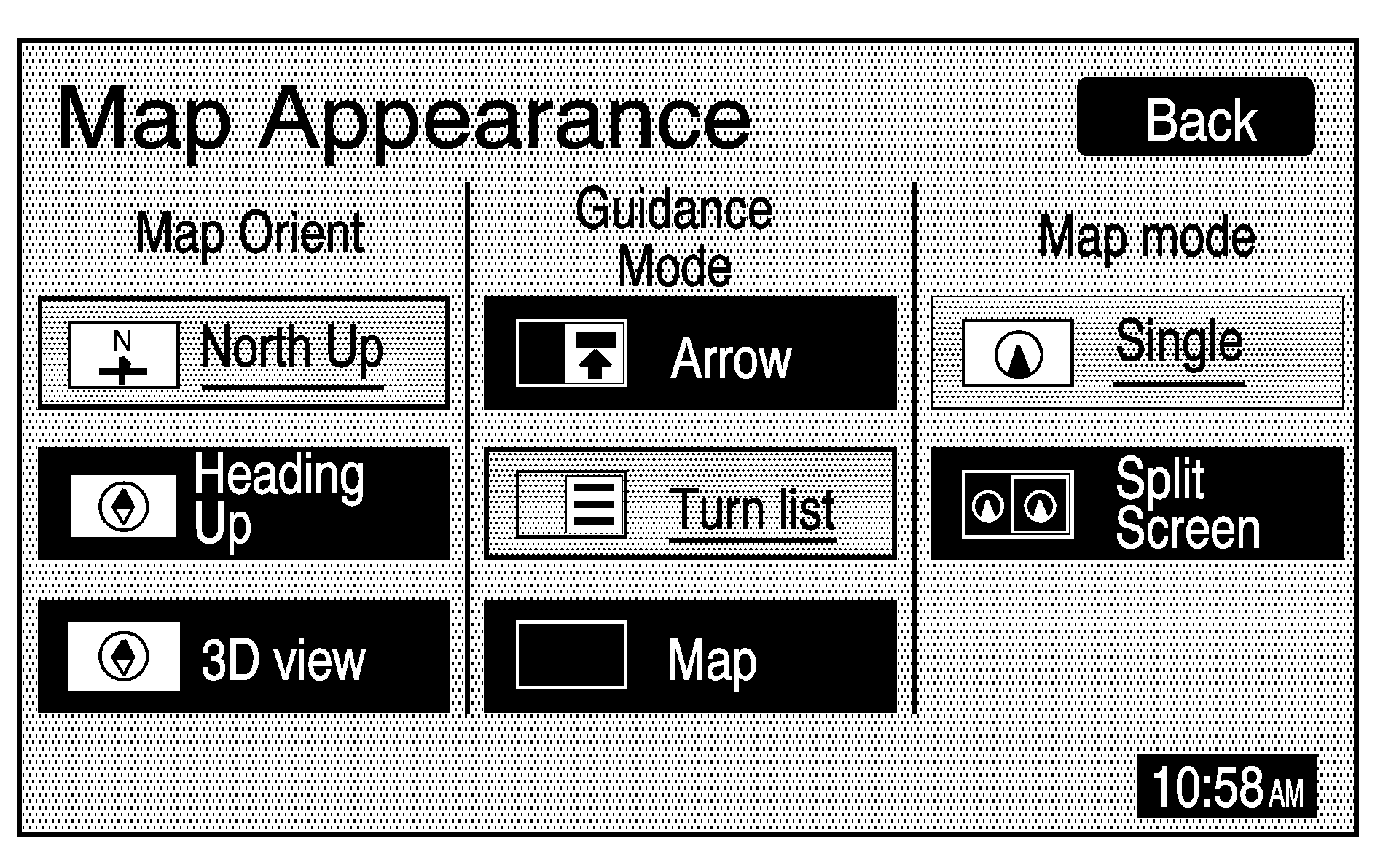
This menu is divided into three sections: Map Orient (orientation), Guidance Mode, and Map Mode. Touch an option's screen button to select it. The following are brief explanations of the options available in each section:
(North Up): This feature orients the map with North at the top of the map screen, regardless of which direction you are driving.(Heading Up): This feature orients the map with the direction you are driving at the top of the map screen, regardless of which direction is North.
(3D view): This feature gives maps a 3-dimensional view, and will remain in the Heading Up position.
(Arrow): This feature continually displays directional turn guidance for your next maneuver.
(Turn list): This feature lists information on your next three maneuvers, including the distance to the turn, and street names.
(Map): This feature will display your vehicle's current position, with the calculated route highlighted.
(Single): This feature allows one map to be displayed.
(Split Screen): This feature allows two maps to be displayed, which can be independently adjusted in both scale and map orientation.
For more information on the symbols that can appear on a map screen, see Symbols.
Voice Volume
(Voice Volume): Select this screen button to adjust the volume of the voice guidance prompts that provide various messages as you approach points where you need to maneuver your vehicle, such as an intersection.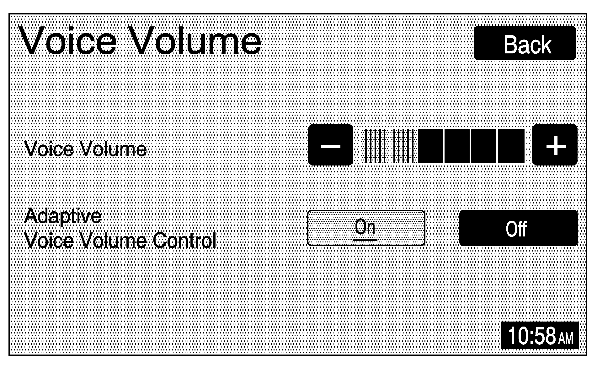
To adjust the volume of the voice prompts, do the following:
- Touch the Voice Volume screen button.
- Touch the plus (+) or minus (-) sign screen buttons to increase or decrease the volume. The voice prompt will come on with each adjustment to give you an idea of the volume at each level.
- Once you have reached the desired volume level, touch the Back screen button to return to the previous screen.
If voice guidance is not needed, lower the volume as far as it will go, so the voice prompts are not heard.
Edit Route
(Edit Route): Select this screen button to recalculate a route based on your preferences.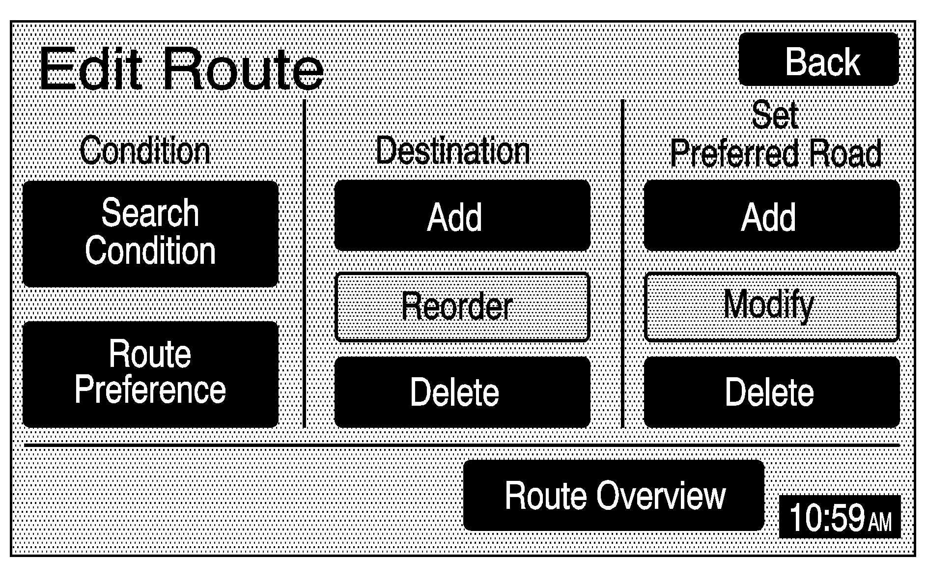
Search Condition: This screen allows you to select your route preference by choosing from Fastest, Shortest, or Alternative route. By selecting the Fastest route, you will be routed along main roads and highways, which does not necessarily mean it will be the shortest route.
Route Preference: This screen allows you to select your road preferences by setting which types of roads you want to use or avoid.
Freeway: This option allows the system to use major roads when calculating a route.
Toll Road: This option allows the system to use toll roads when calculating a route.
Ferry: This option allows the system to use ferries when calculating a route.
Restricted Road: This option allows the system to use time restricted roads when calculating a route.
Destination: This feature allows you to add, reorder, or delete destinations.
Add: See Destination for information on creating a destination.
Reorder: When waypoints have been added, select this screen button to change the order of the waypoints and the final destination on the route.
- Touch the Reorder screen button next to the destination.
- Touch the OK screen button when finished reordering.
- Touch the Back screen button, then the Route Overview screen button. The map screen will display.
- Touch the Route screen button and the system will recalculate the route.
- Touch the Start screen button to start route guidance.
Set Preferred Road: This feature allows you to add, modify, or delete road preference settings.
Add: Press this screen button to add a road. The map screen will display. Touch the map to scroll to the preferred road. Select the OK screen button. Press the Enter screen button to set the road as a road to be added to the current destination or the Next screen button to change the road type.
Modify: Press this screen button to change the preferred road. Follow the directions for the "Add" screen button.
Delete: Press this button to delete road preference settings.
Route Overview: Touch this screen button to access the Route Overview menu. See "Route Overview" under Destination.
Route Preview
(Route Preview): Select this screen button once route guidance has begun to display the map screen with the route highlighted.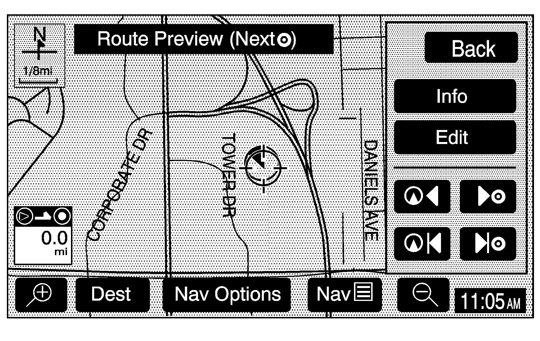
The route is traced by the vehicle symbol as you travel. You can preview the route from the starting position to the final destination by touching the arrow screen buttons inside the Route Preview pop-up menu.
Info (Information): Touch the Info screen button to view POI information such as the POI name, address, and phone number, if available.Edit: Touch the Edit screen button to select a POI as the next destination you would like to preview. To preview a POI's destination instead of the final destination, do the following:
- Touch the Edit screen button.
- Touch the Select POI screen button.
- Touch the screen button of the desired POI category.
- Touch the icon screen button of the desired POI, then touch the OK screen button.
- Touch the Back screen button twice to get to the Edit Route Preview screen.
- Touch the Next POI screen button, then touch the OK screen button.
- Touch the Back screen button to return to the Route Preview screen.
Now when you touch the arrow screen buttons to preview the route, it will trace the route to the next selected POI rather than the route to the final destination.
To return to previewing the route to the final destination, do the following:
- Touch the Edit screen button.
- Touch the Next screen button.
- Touch the OK screen button, then the Back screen button to return to the Route Preview screen.
Now when you touch the arrow screen buttons to preview the route, it will trace the route to the final destination rather than the route to the next POI.
Use the following arrow screen buttons from the Route Preview pop-up menu to trace a route:
(Preview to current location): Touch this screen button to preview the route traveling toward the vehicle's current location. Touch this screen button repeatedly to increase the speed at which the indicator will trace the route.(Preview to final destination): Touch this screen button to view the route traveling toward the final destination. Touch this screen button repeatedly to increase the speed at which the indicator will trace the route.
(View current location): Touch this screen button to view the vehicle's current location along the current route.
(View final destination): Touch this screen button to view the final destination along the current route.
Navigation Setup
(Navigation Setup): Select this screen button to display the Nav Setup menu.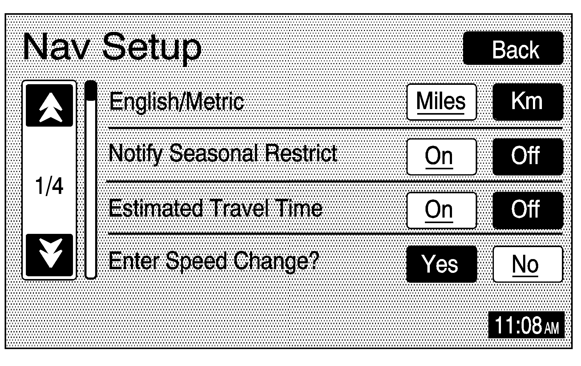
From this menu, several options may be selected, adjusted, or turned on and off. Touch the up or down arrow screen buttons to the left of the menu options to scroll through the list. The following are the available options with a brief explanation of each:
English/Metric: This feature switches distance measurements between English or metric. Touch the Miles screen button for English measurements, or the Km (kilometers) screen button for metric measurements.Notify Seasonal Restrict (Restrictions): This feature notifies the driver of seasonal maneuver restrictions. Touch the On screen button to have a voice prompt warn of existing seasonal restrictions played at guidance points. Touch the Off screen button to turn this feature off.
Estimated Travel Time: This feature displays the estimated time to travel from your current position to the destination. Touch the On screen button to have the estimated travel time displayed with the distance to destination, or the Off screen button to turn this feature off.
Enter Speed Change?: This feature allows you to adjust estimated speeds for Freeway, Main street, or Residential driving. These speed values are used to calculate estimated travel time. To change estimated speeds, touch the Yes screen button. The Change Speed menu will appear. Touch the arrow screen buttons under each road type to increase or decrease the speed. The maximum allowable speed to set is 100 mph (161 km). You may also touch the Default screen button to choose factory default speed settings as your choice. When your adjustments are complete, touch the Back screen button to return to the Nav Setup menu.
Auto Reroute: With this feature on, the navigation system will automatically recalculate a route if you drive off course. Touch the Off screen button to turn this feature off.
Voice Guide in All Mode: Touch the On screen button to hear navigation voice prompts while in Audio mode. Touch the Off screen button to turn this feature off.
Current Street Name: Touch the On screen button to display the current street name that the vehicle is traveling on. Touch the Off screen button to turn this feature off.
Exit Information: This feature will display map icons which can be selected to display the next exit's information, including Point of Interest (POI) facilities such as gas stations, restaurants, and lodging. Touch the On screen button to display exit information icons, or touch the Off screen button to cancel the display of exit information icons.
Map Color (Day): This feature allows you to adjust the daytime map appearance. Choose between Normal, Auto, 1, 2, 3, or 4. The numbered settings vary the color scheme of the map display. The Auto setting will change the map appearance automatically every three months. When the desired color setting has been selected, press the NAV hard key to view the adjusted map color.
Map Color (Night): This feature allows you to adjust the nighttime map appearance. Choose between Normal, Auto, 1, 2, 3, or 4. The numbered settings vary the color scheme of the map display. The Auto setting will change the map appearance automatically every three months. When the desired color setting has been selected, press the NAV hard key to view the adjusted map color.
Calibrate System?: This feature will calibrate wheel speed to assist in the calculation of vehicle position. This feature also allows you to manually reposition the vehicle symbol on the map. You may need to calibrate the system following a tire change, rotation, or if your vehicle has been relocated a great distance. Touch the Yes screen button to calibrate the system, or the No screen button to leave the calibration as it is. See Vehicle Positioningfor more information.
Select Defaults?: This feature allows you to restore all available factory default settings in the Nav Setup menu. Touch the Yes screen button to restore defaults, or the No screen button to retain the current settings.
Memory Points
(Memory Points): Select this screen button to display the Memory Points menu. This menu contains options for registering, deleting, and editing marked points stored in memory, such as memory points, preset destinations, and areas to avoid.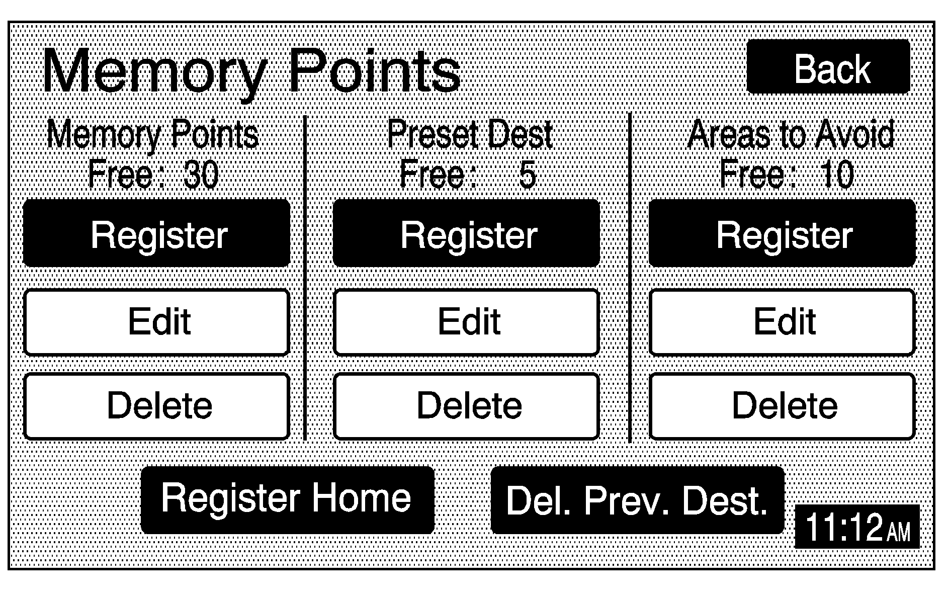
Memory Points: Choosing to add a memory point will take you to the Destination menu. See Destination for more information on how to register Memory Points. You may register up to 30 memory points. The name, location, information, and icon for a memory point can be edited.
Preset Dest (Destination): Five preset destinations, as well as one for home, may be registered or edited. The five preset destinations and home are the only destination selections available from the Destination menu while the vehicle is moving. These presets are shown as the home symbol and numbered presets 1 through 5 at the bottom of the Destination menu. See Destination for more information on how to register preset destinations.
Areas to Avoid: Up to 10 areas to avoid may also be registered from the Memory Points menu. Areas to avoid include areas such as high traffic areas, construction areas, or any main roads, or intersections you want to avoid. When registering or editing an area to avoid, the size of the area may also be increased or decreased by touching the up or down arrow screen buttons on the scroll bar.
Register Home: Touch this screen button to access the Register Home screen. Choose a method of destination entry and enter the destination you would like to store as home. Once your entry is complete, touch the Register Point screen button to store this point as home. Each time you touch the home symbol from the bottom of the Destination screen, this destination will be calculated. Once you have stored a destination as home, the Register Home screen button will change to read Delete Home. You may then touch this screen button to delete the destination you have stored as home.
Del. Prev. Dest. (Delete Previous Destination): Touch this screen button to delete a previous destination. A list of previous destinations will display on the Delete Previous Dest screen. Touch the screen button next to the previous destination you wish to delete. You will be asked to confirm your decision. Touch the Yes screen button to delete the destination or touch the No screen button to cancel the deletion. You may also touch the Del. All screen button from the Delete Previous Dest screen to delete all previous destinations listed. You will be asked to confirm this decision as well. Touch the Yes screen button to delete all previous destinations or touch the No screen button to cancel the deletion.
